Maps
Description of the Maps (Info)
Trend Surface Maps – a 2014 update
The maps published in the 1989 edition of Celtic Coinage of Britain were based on fewer than twenty thousand reported findspots. Since that time, the number of recorded finds has doubled, suggesting there ought to be new insights.
In the mid 1990s, it was widely believed the volume of new data would make a difference in geographical interpretations. A large number of workers expended considerable effort in that direction over the last twenty years – their publications are listed in the bibliography.
Surprisingly, these publications have not resolved many of the controversies from long ago.
It has not been proven either way, for example, whether the Dobunni had one or two issuing authorities. Similarly, there is no proof the Trinovantes, Atrebates, Regni and Catuvellauni issued distinct coinages, or whether the tribes north or south of the Thames shared coins within wider regions. There is also no agreement whether "sub-tribal" coinages existed at all.
In the early 2000s, a new attempt was made to identify a separate coinage for the Belgae (previous ones had turned up nothing). This latest attempt relied heavily (but not entirely) on some 65 new types, all discovered since the early-1990s. Not all workers, however, have accepted a Belgic coinage.
Part of the problem is there little agreement on what the maps reveal. They are usually used to delineate political boundaries. Yet, there is no universal agreement that political processes drove a coin from the mint to its ultimate burial site. Most workers now believe economics was a driver, others suspect social factors played a part. Despite the controversy, there has been no investigation into the ways the coins were used. If gold staters were simply bride-gifts, the maps may show nothing more than locations where weddings took place.
Furthermore, the techniques of interpretation have never been agreed on. How important are "voids" in the maps? How much separation is needed to say two coins come from separate tribes? Is it reliable to interpret dot-maps by themselves, or do you need additional statistical calculations? How much data is required to draw any conclusions at all? The list of nagging doubts goes on and on.
Another problem is that of data integrity. The Haslemere Forger and others, continued to produce fake coins. These forgeries were routinely reported as genuine coins to the various individuals and organizations recording findspots.
These record-keepers were never organized to be authentication bureaus. They recorded coins as they were reported, and no systematic procedure was created to weed out fakes. Although an occasional fake would be identified and marked out, not every coin received intense scrutiny. Some finds were reported with just a photograph (or simply a verbal description) – nothing reliable on which to base an authentication.
It would be impractical to apply formal stylistic, die cutting, metallurgical, metallographic and metrological analyses to every coin found – just to record a findspot. The record-keepers should not be criticized for the forgeries that crept into the numismatic record. Unfortunately, fakes aren't always identified and some of the spurious data could have tainted map work done after 1989.
All these problems have conspired to produce a situation where the maps have failed to answer most of our questions about the coins. A complete re-evaluation of the intellectual underpinnings of map production and interpretation is needed. Until this is done, the maps will likely never answer any of our questions.
The maps presented here are from the 1989 edition of Celtic Coinage of Britain. They have not been updated. Thus, new finds and new types have not been included.
Trend Surface Maps – the discussion from the 1989 edition of Celtic Coinage of Britain (note)
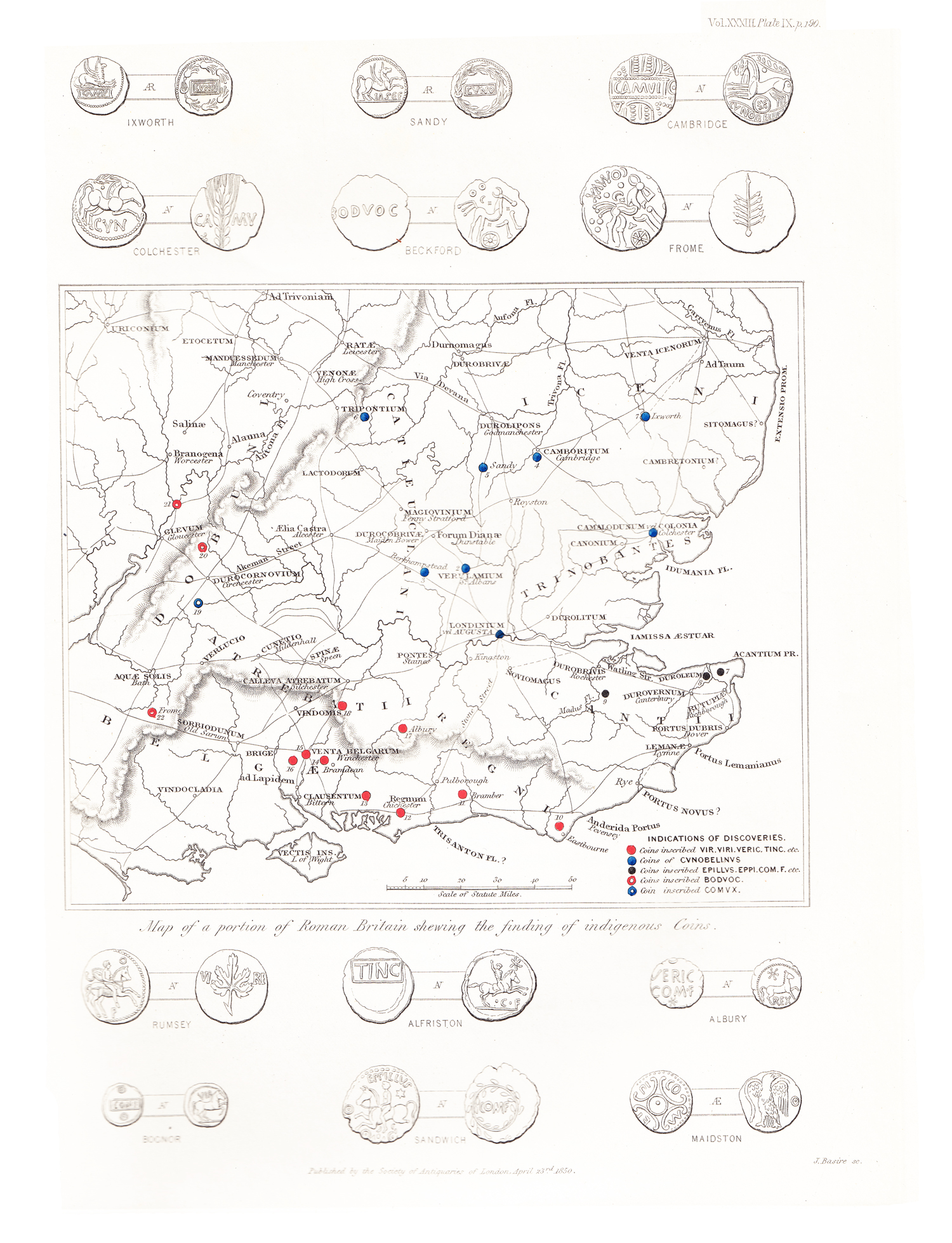
Eighty maps show where the various coin types have been found. Forty different coin types are plotted, two maps for each type.
The first map plots all the coins and answers the question "is this type ever found here?" The second map plots only more frequent (ie: intense) finds and answers the question "where are the coins usually found?"
The maps are not the normal "dot" maps, that is, individual finds are not plotted as points. Instead, the finds have been analyzed statistically, and plotted as contours – the plots are similar to those on weather topographic maps.
The maps help illustrate some themes from the historical section of the book. A discussion of these themes and the interpretation of the maps are given below.
A discussion of the methods used to construct the maps appears at the end of the section. There is also a discussion of the problems associated with distribution maps. The interpretations offered below should be viewed with an understanding of these problems.
Theme 1 – The "Thames Mouth" Distribution
The early imported coins and the Kentish Cast Bronzes are found around the mouth of the Thames. Tribal territories are not well defined by the distribution of these coins.
The finds of Gallo-Belgic A, B and C (maps 1 to 6) fall mostly in the territories of the Trinovantes/Catuvellauni, Cantii and Atrebates/Regni/Belgae. Most Gallo-Belgic A coins are found east of London and on the Essex coast. Gallo-Belgic B occur near London and in east Kent, and Gallo-Belgic C east of London. A few coins are found near Hengistbury and Dorchester, in the territory of the Durotriges. Gallo-Belgic B and C are generally too rare to say their distributions are different from each other or from Gallo-Belgic A.
Cantian A to D (maps 9 and 10), the cast bronzes of the Prototype, Experimental, Innovative and Optimization Periods are also around the mouth of the Thames. Most are found near London, Eastbourne, the Hengistbury area and in east Kent. The distribution is about the same as for Gallo-Belgic A, B and C. The stronger south Thames focus, however, suggests a Cantian origin for these pieces. The distribution of Cantian E (maps 11 and 12) is similar to these types, suggesting a date not much later than the Gallic War.
Cantian cast bronzes are also found well inside Durotrigan territory, often in hillforts. They may have been imported as scrap metal after the coins went out of use sometime after 50 B.C. (116).
Theme 2 – Durotrigan Interaction
Before the Gallic War, the Durotriges had trading contacts with their neighbouring tribes (117).
Gallo-Belgic A and C coins are found in Durotrigan territory (maps 1 and 5), possibly arriving via Atrebatic/Regnan/Belgic intermediaries. Cantian A to D coins also appear (map 9), but these may not have arrived as circulating coins, but instead as scrap metal.
Most importantly, Durotrigan A and E coins, Chute staters and Abstract Type silver staters appear in Atrebatic/Regnan/Belgic territory (maps 55 to 58), and Atrebatic A coins, the Westerham Type, appear in Durotrigan territory (maps 17 and 18). The finds suggest a trading link existed between the Hengistbury and Chichester/Hayling Island regions prior to the war – there may have been coastal traders plying the British coast. However, some evidence for an exchange zone north of the New Forest has recently been discovered (118). Traders may have carried the coins using a northern route between the two tribes.
Durotrigan A and E types also appear in Dobunnic territory in small numbers, suggesting trading contacts, but there were no Dobunnic coins at this time to show the reciprocal relationship. Significantly, Durotrigan A shows two "arms" – one aiming at Camerton, the other towards Bagendon (map 55) – suggesting a pre-war importance for these places. More finds are needed, however, to prove the importance of these places in Durotrigan trade.
Theme 3 – Durotrigan Isolation
At some time during the Gallic War, the Durotriges became isolated from the other tribes. Durotrigan and Atrebatic coins, for example, no longer cross the frontier between these two tribes. This isolation became complete after the war, and interaction was never reestablished – coin exchange between the Durotriges and the other tribes ceased.
Gallo-Belgic E coins, the Gallic War Type, completely shun Durotrigan territory (map 7). Later Cantian coins do not appear (maps 11 to 16), and Atrebatic B coins appear only in small numbers in the east (maps 19 and 20). The way the very late Atrebatic L coins skirt Durotrigan territory (maps 31 and 32) is possibly significant – it may delineate the path of Caratacus as he fled before the Romans.
Similarly, Durotrigan coins no longer appear outside Durotrigan territory. Postwar types Durotrigan I and K, the Silver Starfish and cast bronzes only appear in Durotrigan territory (maps 59, 60, 63 and 64).
Durotrigan J, the struck bronzes do appear in Dobunnic and Atrebatic/Regnan/Belgic territory (maps 61 and 62), but, as Allen noted, it is difficult to distinguish a struck bronze from the core of a forged silver stater. Thus the distribution of Durotrigan J is possibly contaminated with earlier Durotrigan E intruders – some forgeries of silver staters are likely included in the struck bronze map. Alternatively, an earlier date for Durotrigan J is possible, but not enough information exists at this time to fix it with more accuracy.
The great outpouring of gold types Gallo-Belgic E and Atrebatic B may have been caused by an influx of gold provided by the Romans. By financing the Atrebatic/Regnan/Belgic competition for war materiel in Britain, the Romans could have prevented the Durotriges from obtaining goods for the Venetii (119).
Theme 4 – Trading Networks During the Gallic War
The great quantity of gold staters imported during the Gallic War spurred trade within Britain. The results of this show clearly in the coin distributions (120). Coins are found in areas that did not have them before, and several places now stand out because of he large numbers of coins found.
The distributions of Gallo-Belgic D, E and F (maps 7 and 8), Atrebatic B (maps 19 and 20) and Trinovantian D, E and F (maps 65 and 66) show the wartime trade networks. There are important similarities in the distributions.
Imported coins now appear in Icenian, Dobunnic and Corieltauvian territory in quantity for the first time. The imported coins still appear around the Thames mouth – Gallo-Belgic E show a similar distribution in this region as Gallo-Belgic A. Thus the Trinovantes/Catuvellauni, Atrebates/Regni/Belgae and Cantii still shared in the trade.
Atrebatic B, the Atrebatic Abstract Types show the Chichester/Hayling Island, Eastbourne, north Kent, Verulamium/Harlow, Camulodunum and Oxford/Dorchester-on-Thames regions as important nodes in the trading networks. One "arm" extends to Bagendon – suggesting the Atrebates were vying with the Durotriges for the Dobunnic trade. Camerton, however, does not show up in the Atrebatic B maps.
Atrebatic B shows the most widespread influence of the Atrebates/Regni/Belgae, later Atrebatic/Regnan/Belgic coin types show a much more limited distribution – as the Trinovantes/Catuvellauni became more influential at their expense.
Trinovantian D, E and F, the Whaddon Chase Types show the Chichester/Hayling Island, Verulamium/Harlow and Camulodunum nodes, and "arms" extending to Bagendon, again, and also to the Thetford/Norwich areas (maps 65 and 66). The Bagendon and Thetford/Norwich links show the early influence of the Trinovantes/Catuvellauni in Dobunnic and Icenian territory.
Interestingly, small numbers of Trinovantian/Catuvellaunian coins appear in the Chichester/Hayling Island region from this time on, but Atrebatic/Regnan/Belgic ones do not appear at Verulamium/Harlow. This suggests the Trinovantes/Catuvellauni became the key trading tribe, and their coins eventually became the trading currency.
Theme 5 – Trackways in Britain
Two ancient trackways, attested in the archaeological record also appear on the coin maps.
Segments of a trackway along the "Jurassic Ridge", from Corieltauvian territory to Dobunnic territory show in the distribution of Corieltauvian B, C to H and I to R, the North East Coast (horse left variety), South Ferriby and Dynastic Types (maps 41 to 45). The trackway is also suggested by the distribution of Dobunnic D and F (maps 51 and 53).
The Stour Valley trade route between Durotrigan and Dobunnic territory shows in the distribution of Dobunnic B, D and F, the dynastic coins of Corio, Antedrig and Eisv (maps 47, 48, 51 and 53) and Durotrigan A and E (maps 55, 57 and 58).
Theme 6 – Restricted Coin Distributions After the Gallic War
After the Gallic War there was less coin exchange between the tribes, and the maps show the tribal territories with greater clarity. The exception is the Trinovantian/Catuvellaunian coinage, which becomes widely used throughout Britain (121).
Except for a few coins in the Chichester/Hayling Island region, Cantian F, G and H, the Weald Types, appear only in Kent – thus defining Cantian territory (maps 13 and 14). The later dynastic types, Cantian I to N appear in quantity primarily in Kent (maps 15 and 16).
Atrebatic C, D, E and F, the dynastic coins of Commius and Tincomarus appear primarily in the Chichester/Hayling Island region and in the area to the north (maps 21 to 24). Only a few Commius coins appear in Kent, and none of those struck by Tincomarus. Verica's coins, Atrebatic I, J and K show a similar distribution, but with a few coins found in the Eastbourne region (maps 29 and 30).
Durotrigan I, the Silver Starfish Types, appear only in the Hengistbury area, and the cast bronzes, Durotrigan K, have a similar distribution (maps 59, 60, 63 and 64).
Trinovantian I, J and K, the dynastic issues of Addedomarus, show a wider distribution than the coins of other tribes. They spread into Dobunnic and Icenian territory (maps 67 and 68). However, they no longer appear in quantity in the Chichester/Hayling Island region, as the earlier Trinovantian D, E and F types had (maps 65 and 66).
Overall, inter-tribal contact, as shown by coin exchange, decreased immediately after the Gallic War. The widespread use of Atrebatic/Regnan/Belgic coins, as seen in the distribution of Atrebatic B stopped immediately. Trinovantian/Catuvellaunian issues eventually replaced them and finally became the trade coins of Britain.
Theme 7 – Trinovantian/Catuvellaunian Expansion
The expansion of Trinovantian/Catuvellaunian influence, if not actual political control, gradually increased after the Gallic War (122).
Addedomarus begins the process. During his rule, quantities of Trinovantian/Catuvellaunian coins appear in Cantian and Icenian territory for the first time. Trinovantian I, J and K show a much wider distribution than the earlier types (maps 67 and 68). The Camulodunum, Verulamium/Harlow and Oxford/Dorchester-on-Thames regions show plainly on the maps.
Dubnovellaunus-in-Essex continues the influence in Cantian and Icenian territory (maps 69 and 70). Although the Oxford/Dorchester-on-Thames region does not appear because of the scarcity of the coins, the Thetford/Norwich region and north Kent show plainly.
During the reign of Tasciovanus, the coin distributions show an even wider spread (maps 71 and 72). Trinovantian M, N and O now start to south of the Thames in Atrebatic/Regnan/Belgic territory, and north towards Corieltauvian territory.
The coins of the Interregnun (maps 73 to 78) are very rare and not too much significance should be read into their distributions. The maps merely indicate the coins are Trinovantian/Catuvellaunian ones. However, the distributions are based on too few coins to prove, statistically, the types favour one area of the tribal territory over another.
Cunobeline completes the expansion, showing the widest distribution of all (maps 79 and 80). Trinovantian T, U, V, W and X appear throughout the southeast of Britain, even the Chichester/Hayling Island region. They overrun Kent, and Cantian coinage disappears entirely. Cunobeline's coins also appear in Dobunnic territory, in both the Bagendon and Camerton areas, though the distributions there are not so well defined. A few of his coins even appear in Corieltauvian territory.
The expansion of Trinovantian/Catuvellaunian influence, traditionally credited to Cunobeline, may be seen instead to have its roots in the reign of Addedomarus. During the reigns of Addedomarus, Dubnovellaunus-in-Essex, Tasciovanus and Cunobeline, there was an increasing spread of the coins throughout Britain.
The growth of Trinovatian/Catuvellaunian influence and the decline of Atrebatic/Regnan/Belgic are likely to be the result of Roman manipulation. After Commius fled Gaul to join the British portion of his tribe, the Atrebates/Regni/Belgae would have fallen into disfavour amongst the Romans. The Trinovantes/Catuvellauni would have been the natural recipients of Roman support, since they had cooperated with Caesar's incursions into Britain during the Gallic War. It is likely they received special favour (possibly trading rights for Roman goods) and Addedomarus and his successors used this to their advantage.
Theme 8 – Atrbatic/Regnan/Belgic Disfavour After the Gallic War
The position of the Atrebates/Regni/Belgae changed drastically after the war, and this shows clearly in the coin distributions. The coins of Commius, Atrebatic C (maps 21 and 22), are much rarer and circulate in a much-reduced area compared to Atrebatic B (maps 19 and 20). It should be kept in mind, however, that rarer types normally show a more restricted distribution. This is partly because the outer contour lines "disappear" as the total number of coins becomes smaller.
Theme 9 – Atrebatic/Regnan/Belgic Incursion into Kent
During the Trinovantian./Catuvellaunian Interregnum, an Atrebatic/Regnan/Belgic ruler, Eppillus, invaded Kent. Some of Eppillus' coins appear only in the traditional Atrebatic/Regnan/Belgic territory, notably the Atrbatic G "Calleva" Types (maps 26 and 26).
However, others appear primarily in Kent – the Atrebatic H Types (maps 27 and 28). These were the coins used to finance the incursion. A few of these appear in the Camulodunum and Verulamium/Harlow regions, perhaps brought back from Kent by Trinovantian/Catuvellaunian troops after the incursion was suppressed by Cunobeline.
These 10 – Dobunnic Rulers
Allen suggested the Dobunnic rulers were paired, one ruling in the northern part of Dobunnic territory, the other in the south (123). The best evidence was the coin distributions of Corio and Bodvoc – the coins seemed to be found in different areas. Corio's were primarily found in the south and west, Bodvoc's to the east.
The distributions for Dobunnic B and C (maps 47 to 50) show this can no longer be accepted (124), Corio's coins completely encompass the territory of Bodvoc's, and the distribution for Corio shows both the Bagendon and Camerton centres. In the past, Bodvoc's coins seemed to occur only around the Bagendon centre, but an example is now known from Bath, so the distribution of "all coins" is now wider than before.
Although Corio's uninscribed silver types (1042-01, 1045-01 and 1049-1) are plotted with the inscribed gold, there is no significance for the two metals. When gold is plotted alone, for example, it shows about the same contours, reveals the Camerton and Bagendon centres, and overlaps all but the most easterly of Bodvoc's coins.
Bodvoc's coins are generally rarer than Corio's, and would naturally show a more restricted distribution. If more finds were known, the distribution for Bodvoc would be wider still.
Thus, the idea of mutual exclusivity, the proof for Allen's argument, is no longer tenable. At best, it could be asserted Bodvoc's coins shun the south and west of Dobunnic territory, but there is little proof. Certainly, the distribution of Corio's coins overlaps those of Bodvoc's.
Constructing the Trend Surface Maps
The methods of constructing trend surface maps are discussed in detail elsewhere (125) and will not be elaborated here. Findspots were taken from Allen 1960, Haselgrove 1978 and Haselgrove 1984a.
The findspots were first plotted on a map. Hoards were treated in two ways. Those with a narrow range of types – many of these would have been "concealment hoards" – were treated as a single find. Hoards with a wide range of types, often individual coins collected over a long period of time, were treated as if each coin were a single find. Many of these hoards represent "temple offerings" or "temple savings". The hoards were treated differently because the first type would emphasize certain locations unfairly, but the second kind would be more representative of coin use in a region over time.
Modern forgeries (which had crept into the records) have been deleted, and the many inaccuracies in the National Grid Coordinates for the findspots corrected.
The attribution of coins follows the catalogue listings, not the attributions of previous workers. For this reason, Gallo-Belgic D and Allen's "British O and P" are not plotted – the records confuse types and they cannot be disentangled. However, Allen's British Lx, Ly and Lz have been reattributed and are included.
The maps for Durotrigan J, the cast bronzes, are probably compromised by the inclusion of cores of forged silver staters, and for this reason maps 61 and 62 are suspect, though it was decided to include them despite the problems.
Maps were not prepared if the types were too rare to reveal distributions adequately.
The Maps were then gridded off in 32 km (20 mile) squares. This grid size was chosen because each square encompasses enough coins to give useful averaging, but the grid is still fine enough to resolve (ie: distinguish) major regions, like Camulodumun and Verulamium/Harlow. It does not resolve local sites; for example, Oxford, Dorchester-on-Thames and other sites in that vicinity are all shown as a single, blurred area.
Thirty-two km squares do not produce extreme "edge effect" distortions. Edge effects mostly occur near coastlines, where averages are calculated using the "zero finds" in the water areas. On the maps, edge effects are generally small and show up primarily in the Icenian and Cantian territories.
One other attempt was made to eliminate edge effects – the placing of the grid corner. The grid corner was placed at National Grid Coordinate SX (20) 500 500 for all the maps, except the Dobunnic ones. This placement helps minimize edge effects for a 32 km square grid, especially in Icenian territory.
Dobunnic B, C, D and F, however, were constructed with a grid corner shifted slightly – to ST (31) 000 000. This shift resolves Camerton and Bagendon as two sites – instead of a single, elongated area. For these maps, the edge effects in Icenian territory are acceptable because that region is not important for Dobunnic coins.
The number of coin finds in each square was then counted.
The process known as "grid generalization", a smoothing technique, was done in the simplest manner. The average value of four adjacent squares was place at the intersection of each group of four. The contours were then drawn in without resorting to regression analysis. Each contour line connects equal frequency of coin finds (per 32 km square) averaged over a 4096 km (1600 square mile) area.
The upper map in each pair shows the 0.25 coins per 4096 square km contour, it encompasses all known finds. The lower map has an outermost contour of 0.50 coins per 4096 square km, encompassing areas with two coin finds. Higher frequency contours were selected based on the individual requirements of the types – a general scheme was not helpful. Voids are areas in which no coins have been found, these are indicated where ambiguity might occur.
Coins found north of York are generally off the map, and are not included. The important site at Mount Batten is similarly off the map, as is the Carn Brae hoard of Cornwall. Finds in the Isle of Wight are included, but Wight only appears on those maps partly shaded with "voids". That is, the Isle of Wight does not appear totally inside any contour, but is partly included in a few.
Problems of Trend Surface Maps
It is wrong to assume trend surface maps are objective representations just because they appear "scientific". They are actually very subjective, and must be used with care.
First, findspots are often recorded without precision and the reporting of finds is haphazard at best. The activities of local collectors and archaeological groups in the nineteenth century distorted the reporting even further. The importance of some sites on the maps could merely reflect the activities of interested individuals – the old joke about findspot maps showing where people have gone looking for coins should be kept in mind. These problems are probably discussed best in Rodwell 1981.
The methods of constructing the maps can shift the contours and even create "statistical artifacts" – area of seeming importance where none existed. The depiction of Bagendon and Camerton as one big region or two separate sites is an example of this problem. Usually the problem is solved with multiple maps (created using different techniques). These are then compared. In the case of Dobunnic coins, the best representation of the data showed two sites, not one.
The inaccuracy of findspot reports, and the placement of the grid corner can shift a contour – and even a site – several miles in any direction. Thus the maps do not have the precision they suggest.
Despite all these problems, it must be said the maps do have validity. Far too many coins have been found and recorded properly, over a long period of time, for the distortions to have serious impact. The maps based on small numbers of finds can be expected to suffer the most, but those for the commonest, and usually the most important types hardly suffer at all.
The maps could have been constructed to answer many different questions – for example gold coins could have been plotted on different maps from the bronzes. The resulting map pairs might have shown areas within a tribe's influence where small change was used.
The maps in this book were constructed, first, to average as many coins as possible. Secondly, they were plotted with an eye to identifying the early use of coinage in Britain, the growth of trading networks, the extent of tribal territories and the influence of individual rulers.
End